Information Landscape
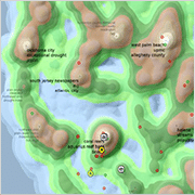
Information landscapes allow clustering and visualizing massive amounts of textual data. They implement the concept of ‘location’ in an innovative way that transcends the traditional geographic interpretation. The Information Landscape resembles a geographic map at first sight. Instead of geographic proximity, however, it represents semantic similarity between documents.
At the time of map generation, its topography is determined by the content of the knowledge base. The peaks of the virtual landscape indicate abundant coverage on a particular topic, whereas valleys represent sparsely populated parts of the information space.
Interface Elements
- Captions. The keywords for each peak are calculated automatically, based on the content of surrounding documents.
- Document Markers. The markers the position of the documents from the Nearby Locations window, using color coding to indicate document sentiment.
- Document Selection. Hovering above any location in the map shows a preview of the closest matching document in the active document window, clicking selects this document (each of the small gray dots, which become visible after zooming in, represents one document).
